Karakoram Highway (or KKH)connects China and Pakistan across the Karakoram Range through Khunjerab Pass, which is at an altitude of 4693mts. Karakoram Highway is the highest international road in the world.
It connects China’s Xingiang region with Pakistan’s Gilgit-Baltistan. Due to its high elevation and the difficult conditions in which it was constructed, it is also referred to as “Ninth Wonder” of the world.
This highway is called the Friendship Highway as it was built by governments of China and Pakistan. It was completed in 1986. It took 20 years in construction. It is made on the paths of ancient silk route. It runs approximately 1300 km on the ancient silk route and starts from Hassanabdal, near Islamabad and terminates at Kashgar, Xingiang, China.
Pakistani section
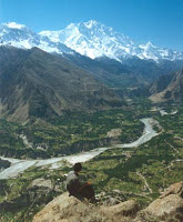
Pakistani section of the highway is 806km long. It starts from Hassanabdal, runs along Indus River. A place comes where Indus river joins Gilgit river, this is the place where three great mountain ranges meet, the Hindukush, the Himalayas and the Karakoram. And the far west end of Himalayas i.e. the last peak of Himalayas, Nanga Parbat (8126mts.) can be seen through this highway.
China section
China section is about 494 km. long. Starting from Kashgar, the road runs along Ghez river canyons between Chakragil and Kongur mountains. From Ghez, it reaches Kirigiz valley. After climbing up the valley the road descends to Tashkurgan. Beautiful views of Muztagh Ata and Karakul Lake can be seen though this part of the road. While a separate road goes to join the Pamir Highway, the main road continues to Wakhjir Pass and finally Khunjerab Pass beyond which Pakistani section begins.
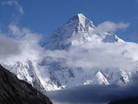
Five of eight thousanders are accessible by this highway which include K2, Broad Peak , Nanga Parbat et c. Notable Mountains that are visible across the road are:
1. Nanga Parbat
2. Rakaposhi
3. Diran
4. Shishpar
5. Ulbar peak
6. Muztagh Ata
Many glaciers can be seen along this highway:
1. Minapin
2. Passu
3. Ghulkin
4. Khunjerab
Main rivers and Lakes along the Highway are:
1. Indus
2. Hunza
3. Gilgit
4. Karakul Lake
KKH is best travelled in spring or early autumn. Heavy snow in harsh winters and monsoon rains in July and August can block the road for hours. The border at Khunjerab Pass is open only between May 1 and December 31 of every year.
Thursday, August 19, 2010
Tuesday, August 3, 2010
Concordia, Karakoram
Concordia (4650 mt.) is the meeting point of the Baltoro glacier and the Godwin-Austin glacier right in the heart of Karakoram range of Baltistan region of Pakistan.
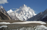
K2 from Concordia
Around Concordia are groups of some of the highest peaks, four of which are 8000 meters above including K2, Broad peak and Gasherbrum I and II. This place is the heaven for tourists who are not involved in climbing. This place provides spectacular views of these peaks and other lower peaks. It also provides short hikes to several important base camps: K2 (3 hours), Broad peak (2 hours) and the Gasherbrums ( 3 hours).
Visitors to this region are advised to carefully monitor their water intake with concern.


From top - Broad peak, Muztagh towers and Gasherbrum
Notable peaks of this area are:
K2, second highest in the world at 8,611m.
Gasherbrum I, 11th highest in the world at 8,080m.
Broad Peak, 12th highest in the world at 8,047m.
Gasherbrum II 13th highest in the world at 8,035m.
Gasherbrum III 7,952m.
Gasherbrum IV 17th highest in the world at 7,925m.
Masherbrum (K1), 22nd highest in the world at 7,821m.
Chogolisa 36th highest in the world at 7,665m.
Muztagh Tower 7,273m.
Snow Dome 7,160m.
Biarchedi, 6,781 m
Mitre Peak 6,010m.

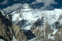
K2 and broad peak from concordia
Monday, August 2, 2010
Karakoram Pass
Karakoram pass is the highest pass (18,250 ft.) lying in the state of Jammu and Kashmir, India. It lies on one of the highest trading routes in the world for Yarkand ( Central Asia). The route starts from Nubra Valley in Ladakh via Murgo, Burtso, Daulatbeg Oldi and finally leads to the Pass.
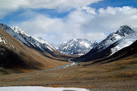

Karakoram pass
The region is absolutely barren with no vegetation. Temperature drops to -30 degrees and storms, blizzards and snowstorms rage throughout the year. From Daulatbeg Oldi, there is a 16km. long trek through the dry river bed. Bones of men and animals are silent reminders along the route that tell us of the hostile conditions that took so many lives.

Bones of men and animals on the way
One thing is clear; this route was extensively used for trade with Central Asia in olden times. Although the pass is not that difficult to traverse, but it is the thin air that makes crossing most difficult. At 5540 mts, this pass is formed by a saddle between two gentle mountain tops. Due to lack of summer snow or ice, the pass was open throughout most of the year. The pass currently remains close to vehicular traffic.
Karakoram Range
Impenetrable, Inhabitable, Majestic, Throne of Gods; these are some of the words used for the Karakoram Range. Karakoram literally means “Black Gravel” in Turkish. Karakoram is home to some of the highest peaks of the world. Four of the world’s fourteen eight thousand plus peaks lie here, these are K2, Broad peak, Gasherbrum I and II.
 Karakoram is a large lofty mountain range sharing its borders between India (Ladakh), Pakistan (Gilgit-Baltistan) and China (Xingiang region). One of the greater ranges of Asia, arising from the Pamirs, this range runs parallel to the Great Himalayas, although not a part of it.
This range is about 500 km in length. Two of the world’s largest glaciers ,i.e., Siachen (70km.) and Biafo (63km.) which are ranked second and third largest outside the polar region lie here only. The first being Fedchenko glacier that is 77 km. long. The Baltoro glacier is significant as it encompasses all the 8000+ peaks of this range.
Karakorams not a part of Himalayas
The Karakorams run parallel to the Himalayas, but its peaks differ from those of the Himalayas in their sharp angular forms. The range houses many tower shaped and spires type of peaks.
Karakoram receives lesser monsoons than the Himalayas. But the peaks experience heavy winter snowfall. In July and August the winter snow melts down and makes travel a difficult task. So, the travelling around this area requires an expedition –style planning.
Karakoram Range is basically characterized by heavy glaciations and dry plateaus. There is no greenery as it doesn’t receive precipitation. This range forms a geographical divide between Central Asia and India. Because of the fact that Karakoram is situated at an extremely high altitude, the area is sparsely populated. Several of the mountain passes such as the Karakoram pass and Nubra pass lie in this region.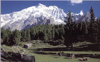

Haramosh peak (7397 mts.), Muztagh Ata(7546mts.) from Karakoram Highway and Rakaposhi(7788mts.) from Hunza valley
Notable peaks of this range are:
• K2 (8,611 m)
• Gasherbrum I (8,068 m)
• Broad Peak (Phalchen Kangri) (8,047 m)
• Gasherbrum II (8,035 m)
• Gasherbrum III (7,952 m)
• Gasherbrum IV (7,925 m)
• Distaghil Sar (7,885 m)
• Kunyang Chhish (7,852 m)
• Masherbrum I (7,821 m)
• Batura I (7,795 m)
• Rakaposhi (7,788 m)
• Batura II (7,762 m)
• Kanjut Sar (7,760 m)
• Saltoro Kangri (7,742 m)
• Batura III (7,729 m)
• Saser Kangri (7,672 m)
• Chogolisa (7,665m)
• Haramosh Peak (7,397 m)
• Baintha Brakk (7,285 m)
• Muztagh Tower (7,273 m)
Karakoram is a large lofty mountain range sharing its borders between India (Ladakh), Pakistan (Gilgit-Baltistan) and China (Xingiang region). One of the greater ranges of Asia, arising from the Pamirs, this range runs parallel to the Great Himalayas, although not a part of it.This range is about 500 km in length. Two of the world’s largest glaciers ,i.e., Siachen (70km.) and Biafo (63km.) which are ranked second and third largest outside the polar region lie here only. The first being Fedchenko glacier that is 77 km. long. The Baltoro glacier is significant as it encompasses all the 8000+ peaks of this range.
Karakorams not a part of Himalayas
The Karakorams run parallel to the Himalayas, but its peaks differ from those of the Himalayas in their sharp angular forms. The range houses many tower shaped and spires type of peaks.
Karakoram receives lesser monsoons than the Himalayas. But the peaks experience heavy winter snowfall. In July and August the winter snow melts down and makes travel a difficult task. So, the travelling around this area requires an expedition –style planning.
Karakoram Range is basically characterized by heavy glaciations and dry plateaus. There is no greenery as it doesn’t receive precipitation. This range forms a geographical divide between Central Asia and India. Because of the fact that Karakoram is situated at an extremely high altitude, the area is sparsely populated. Several of the mountain passes such as the Karakoram pass and Nubra pass lie in this region.


Haramosh peak (7397 mts.), Muztagh Ata(7546mts.) from Karakoram Highway and Rakaposhi(7788mts.) from Hunza valley
Notable peaks of this range are:
• K2 (8,611 m)
• Gasherbrum I (8,068 m)
• Broad Peak (Phalchen Kangri) (8,047 m)
• Gasherbrum II (8,035 m)
• Gasherbrum III (7,952 m)
• Gasherbrum IV (7,925 m)
• Distaghil Sar (7,885 m)
• Kunyang Chhish (7,852 m)
• Masherbrum I (7,821 m)
• Batura I (7,795 m)
• Rakaposhi (7,788 m)
• Batura II (7,762 m)
• Kanjut Sar (7,760 m)
• Saltoro Kangri (7,742 m)
• Batura III (7,729 m)
• Saser Kangri (7,672 m)
• Chogolisa (7,665m)
• Haramosh Peak (7,397 m)
• Baintha Brakk (7,285 m)
• Muztagh Tower (7,273 m)
Subscribe to:
Posts (Atom)